Ski and Alpine Resort Maps


Ski Resort Map of the Alps
The first comprehensive ski-resort focused map of the Alps, showing the positions of 640 resorts, enabling independent travellers to plan their journeys to and through the mountains.
-
attractive, clear mapping showing the location of 640 indexed alpine resorts in Austria, France, Germany, Italy, Liechtenstein, Slovenia and Switzerland
-
complete network of major roads across the region and minor roads serving resorts
-
the position of over 30 airports in, or near, the Alps, highlighting those with their own railway station for an easy onward connection
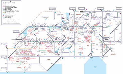

Ski by Train
Much like the iconic topological London Underground Map, this schematic style map sets out to simplify rail journeys to and through the Alps. Featuring 200 ski resorts across seven Alpine countries, it shows access cable cars, mountain railways, main lines and the Eurostar route, making it easy for adventurous travellers to plan their own independent journey to the mountains
-
Covers seven Alpine countries - Austria, France, Germany, Italy, Liechtenstein, Slovenia, Switzerland
-
Includes journey times by train from UK to several Alpine cities
-
31 airports shown and those with their own railway station highlighted to help holiday-makers select routes with an easy onward transfer
Wall Maps

Aside from our folded maps, all our maps are available in a variety of decorative wall map formats and sizes to suit any space and in a variety of media types from laminated maps with stickers to framed canvas prints and foam mounted prints. They can also be personalised to make a unique gift, business tool or simply a wonderful memory of your travels.

To see the entire catalogue of ski maps you can visit our sister site here.
